Having slept fitfully I wake up to see Biot glowing in soft early morning light.


As every morning when traveling in France, I need the buttery hit of a freshly baked croissant. Yarden knows just the place and takes me to an artisanal bakery where he knows that all the ingredients are as locally sourced as possible.

Price hikes and their ramifications seem to be a major problem – even the bakery needs to explain why the prices have risen.

The rest of the morning was filled by…work. There were some very important phone calls to be made and some emails that needed immediate attention. I wasn’t happy at all.

Before leaving, I was invited to eat lunch with Yarden’s parents – home made Mediterranean food: it gave me the energy for today’s stage: driving to Vars via the Col de la Bonette, which is (arguably) one of the highest roads in Europe and was inaccessible last time over due to snow on the road … end of June.
I start at very acceptable 32°C and first head direction Nice, which is around 20 km from Biot.

As soon as Nice came into view, something else came into view, too. A massive weather front! It looked like Armageddon.


Unfortunately, I had to drive exactly in direction of the center of this storm. Winds were picking up and I put on TW560’s canopy as I was expecting the rain to start at any minute.

Which it did. First heavily but then…

Torrential rain combined with high winds started which forced me to stop for a moment. There was so much water everywhere and quite a lot of it was being pushed into the TWIKE by the wind. I’d put this at the second worst weather endured by TW560 – only to be topped by the crazy weather we encountered in Hungary in 2017.
After around 20 minutes storm abated and made way to some more agreeable weather – I was now looking forward to my ascent again.

The first part of the climb was pretty impressive and not too steep.

However, due to the heavy rain, there was consistent rockfall around me and I took a real risk driving on this road right after the rain.

At least I had good news: the pass was open!

And the first cycling signs were to be seen as this is one of the very popular ascents for serious cyclists.

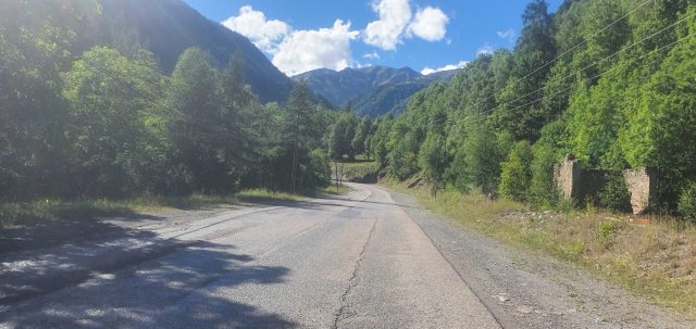
There is not much to say – the views got better by the minute and the temperatures were dropping slowly – giving me a reprieve from the heat I’ve been experiencing during the last few days.


As it’s already past 6, sunlight and shadows are warm yellow, dramatic and long.
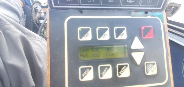
I have to take care not to overheat the motor which means a fine balance between speed and acceleration applied. TWIKE pilots know what I mean: driving slow does not necessarily keep the temperature low since there isn’t enough airflow to transport the heat away…however if you accelerate too much, you will produce more heat than the airflow can carry away, even if the airflow is higher. There is a sweet spot for this and it is different for every single TWIKE.


Above the treeline fast-moving clouds create a dramatic, ever-evolving scenery.
There is still around 800m to climb. At least we’re around 15°C and the wind makes it feel much colder.

The wind and recent rain make the views surreal – such clarity and resolution with clean air – I stop more than once just to admire the view!


The landscape above 2000m ASL starts to look more and more barren – what a surprise to find a snowplow blocking the road!


I got to the 2750 ASL Col de la Bonette, ready for my last ascent to the very top!

It’s another 1.5 km to the top. Finally there, it feels like a great accomplishment! 2802m! 18m higher than the Ötztaler Gletscherstrasse that TW560 had climbed a few years ago.

It’s pretty cold up here! Lucky me I have my trusted soft shell jacket with me as I planned on crossing the French Alps from the very beginning of TDE2022.
<geek-talk>
France’s size means that there are massive parts of the country that require coverage but might have minimal user counts. This was true when crossing the central parts of France driving from Die to Avignon.
Band 28 has only been put into use by the Bouygues Network and does a great job at delivering long-range coverage for rural settings. With a maximum theoretical cell coverage of 178km2 this is *the* frequency in Europe to fill gaps and provide basic connectivity where previously GSM or nothing was the norm.
Whilst the bandwidth dedicated to the cells in central France was a meagre 5 Mhz with no MIMO – this translates to a total of 16 Mbit to be shared between potentially thousands of terminals.
Here, at the top of Europe, so to speak, coverage is great: Band28 with 20 Mhz with 1x MIMO @ LTE-TA of 152. This really makes a difference. No other provider has anything comparable.
I’m still in awe how resilient the signals are and how little TX power is required from the MT! 152 TA with 23 dBm and 23mBit throughput is just incredible!

</geek-talk>
With this it’s time to start the descent towards Col de Vars.

The views are exceptional – I urge you to take the time to come here.

Having arrived in Jausiers, where years ago, we added a last charge to our TWIKE to make it across the pass,
With shadows growing longer, it’s time to get past Col de Vars – from the pass it’s only 4 km to Vars.

Having arrived at my hotel in Vars, the owner immediately made some space in the garage for me to start the charge. Given that I’m leaving early tomorrow and I’m arriving late, this translates to a continuous 8A overnight charge.

The hotel is a typical alpine faux-wood affair trying its best to push our ‘gemütlich’ Buttons with lots of wood and red-ish colours.
It works – my room even had some fairy-lights to complete the romantic setting.
I’m quite tired from today’s drive. Tomorrow another top-ten of Europe passes awaits to be crossed…also: I’m really looking forward to a day in Italy! I open the windows to enjoy fresh 15°C air entering my room. Being at 1670m ASL really makes a difference!
Good night!


